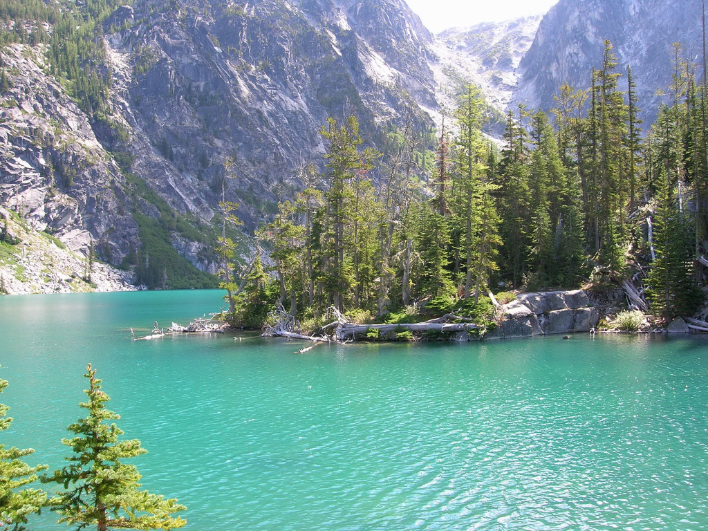
Colin and I ran the Enchantment Lakes circuit in exactly 5 hours. The point-to-point run starts at the trailheaad for Colchuck Lake (3,400 ft) and ends at the Snow Creek trailhead (1,400 ft) with the high point at Aasgard Pass (~7,850 ft) . Total mileage is around 18-19 miles with cumulative elevation gain over 5,000 feet.
Archive for August, 2008
Enchantment Lakes Run
August 28, 2008Fortress-Chiwawa Speed Traverse
August 24, 2008I traversed Fortress Mountain and Chiwawa Mountain in 9:16 roundtrip from the Buck Creek Trailhead at Trinity. Both peaks are located on the cascade crest within the Glacier Peak Wilderness. They are situated perfectly to provide views of the heavily glaciated Dakobed Range and Glacier Peak, which is the most remote major volcano in the Cascade Range. Complete trip report and photos HERE.
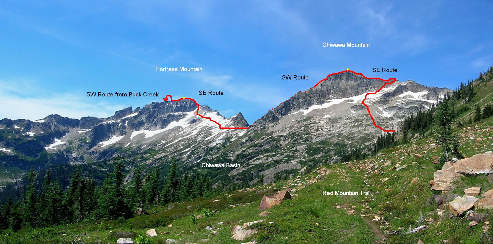
The traverse over Fortress Mountain and Chiwawa Mountain
Where’s Karl?
August 21, 2008
Karl Meltzer has let go of his AT Record attempt (for now) and is waiting for his injured shin to heal before continuing. I received this update from him this morning:
Well Buzz we have some issues. My Tendentious is coming around, and I hope to get back on the trail by Saturday or Sunday. This (trip) really is intense, nothing like going every day all day. It’s my next new step into the world of adventure running. I’m chalking this one up to a learning experience and it’s important to get it done no matter how long it takes, mostly to learn logistics for the 2009 assault number 2. I’m excited to start over next year already.
(more…)
Ptarmigan Speed Traverse
August 16, 2008Colin Abercrombie and I completed the Ptarmigan Traverse in 18:10 from the Cascade Pass parking lot to the Downey Creek trailhead. We set out at 2:05 am and reached the official end at the Suiattle River Road at 8:15 pm. Due to a washout on the Suiattle River Road, we walked an additional 8.5 miles to the car over another 2.5 hours.
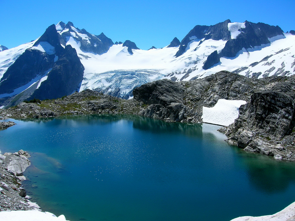
Gorgeous White Rock Lakes
Location (Elevation): Time Elapsed / Split / Real Time
Cascade Pass TH (3,600 ft) : 0 / 0 / 02:05
Cascade Pass (5,392 ft) : 55:03 / 55:03 / 03:00
Cache Col (6,920 ft) : 2:13:13 / 1:18:09 / 04:18
Spider-Formidable Col (7,320 ft+) : 4:59:33 / 2:46:19 / 07:05
Yang Yang Lakes (5,830 ft) : 6:20:09 / 1:20:36 / 08:25
White Rock Lakes (6,194 ft) : 9:50:45 / 3:30:35 / 11:56
Spire Col (7,760 ft+) : 11:54:44 / 2:03:59 / 14:00
Cub Pass (6,000 ft+) : 13:41:32 / 1:46:48 / 15:47
Bottom of Bachelor Creek (2,440 ft) : 16:29:45 / 2:48:12 / 18:35
Downey Creek TH (1,415 ft) : 18:09:36 / 1:39:50 / 20:15
[Car at Milepost 12.5: 20:48:24 / 2:38:48 / 22:54]
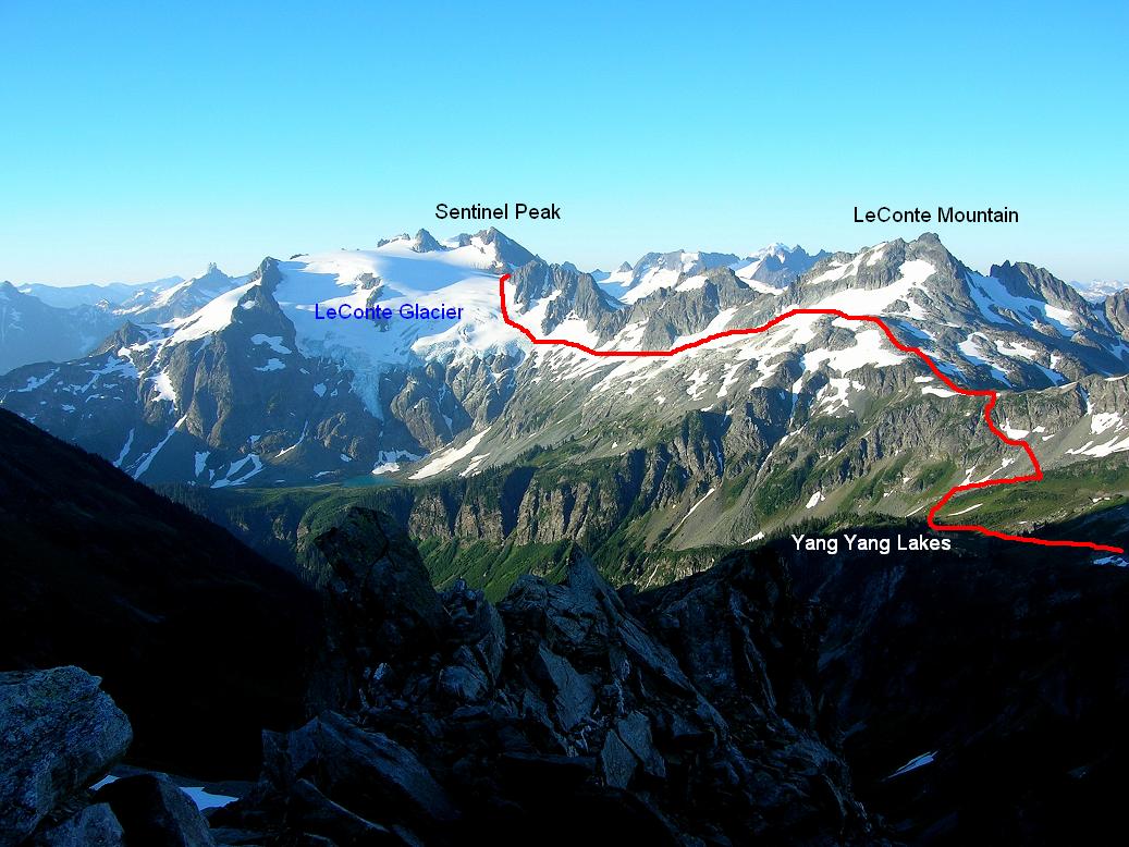
Traverse from Yang Yang Lakes to the LeConte Glaicer
The Ptarmigan Traverse is a high alpine route along the spine of the North Cascades crest traveling through some of the most remote and wild terrain in the contiguous United States. The route was first pioneered by the Ptarmigan Climbing Club over 13 days in July 1938. The second traverse was in September 1953 from the traditional direction. The Ptarmigan has since become world famous for its breathtaking scenery, but it remains remote and challenging and most parties take between 4-7 days to complete the traverse. The fastest known time on the Ptarmigan is held by Joe Stock and Andrew Wexler in 15:40.
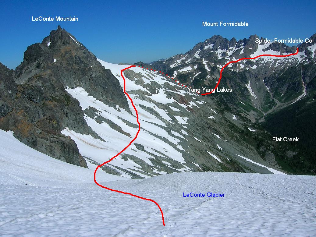
Looking back at the traverse from Spider-Formidable Col
The traverse begins in North Cascades National Park at Cascade Pass, but the majority of the route is located within Glacier Peak Wilderness. Numerous glaciers are crossed en route and routefinding skills are required. After miles of snow, ice, crags, and rock, the Ptarmigan concludes with a classic Cascades bushwhack in Bachelor Creek followed by the old growth forests of Downey Creek.

Traverse to Spire Col
Colin and I did the Ptarmigan Traverse in 2004 over 5 days, which helped immensely with routefinding. Four years ago, we would have never thought to do it in a single push, let alone 18 hours. In discussing this trip, we had hoped to go under 20 hours, but knew it could run longer a la Mount Fury last week. We were able to exceed expectations on the traverse portion, and despite brush-choked Bachelor Creek taking longer than expected, a consistent and focused effort throughout the traverse allowed us to make great time.
Complete trip report and many more photos HERE.
Wind River Range
August 13, 2008
 The “Winds” are iconic. Big, wild, and remote, the Wind River Range in Wyoming triggers the imagination. Seven of the biggest glaciers in the lower 48 frame some of the longest trails in the country, which lead past outstanding granite cliffs rising above clear trout streams and wildflower meadows.
Lisa and I did a 75 mile backpack loop thru the Winds, passing thru the fabled Cirque of the Towers, where I soloed the classic East Ridge of Wolf’s Head. This trip is stretching the definition of “adventure running”, but it is also so good, I just have to tell you about it!
Aug 2 – I do the Eldora Trail 10K race outside of Boulder, go home, take a shower, and hit the road. Going to Wyoming i not an insignificant drive: 7 hrs. The final stretch is 45 miles on a dirt road. The Winds are totally unlike Colorado, where mining activity has left anthrogenetic remnants, such as roads and old buildings, literally everywhere and up to any elevation. In the Winds you drive up to 9,000′ at the most, and then start walking. It’s like driving up to Estes Park from Boulder all on a dirt road, then hiking from there in order to climb Longs Peak. There is no roads of any kind except to the 6 main trailheads, which makes the Range much bigger than it’s actual geographic extent.
Aug 3 – Wake up at the Big Sandy TH after sleeping in the back of the car – there are about 130 cars parked here -and start walking. We head up the West side of the Range, which is quite different than the Eastern half. The nicest and maybe most popular section of the CDT (Continental Divide Trail) goes from our start at the Big Sandy TH up to the Green Lakes TH, the trails on this side are well signed and maintained, and there are various stock and pack animal operations at the lower elevations. So we make good time on a good trail, over surprisingly gentle terrain, and are approaching Kagevah Pass in late afternoon. At this point the trail becomes a cairned route, which is good – its nice to pick one’s way thru the terrain, paying attention as you go. Once over Kagevah, everything is different. We head down into the trees after a 13 hour day for our first camp.
Aug 4 – The Eastern half is the leeward side of the Range, which may mean less snowfall but much more snowpack due to drifting. Thus, there are large permanent snowfields and glaciers, forming deep valleys, big rivers, and sharply incised granite walls towering above it all. So much to climb, so little time! This section is also on the Indian Reservation, which means limited access. The “trails” are mostly cairned routes, and we spend much time picking our way thru downed trees and around marshes; our mile per hour hiking speed drops dramatically. It’s good. Early on the first day we saw but did not encounter three other parties, and during this section we see no one; indeed, little sign of humans at all. All those cars back at the TH unloaded people who mostly stay to the main trails. I am guessing: human use of the Wind River Range has probably doubled in the last 10 years. That means 10 times as many people trying to climb Gannett Peak, 10 times as many people hiking the CDT, 10 times the people going to the Cirque … and HALF as many people going to the other 99% of the Range.
Aug 5 – Waking up from another 13 hour day, we leave our little camp at the highest clump of trees and head up Teepee Pass. I differentiate “backpacking” from “mobile camping”. We are basically here to hike … we like to hike, so that’s what we do. A day consists of waking up, loading the pack, and start walking. I eat some nuts and dried fruit as we go, and late morning we stop, re-organize the maps, take our shoes off, and eat something more substantial (Grape-Nuts for me). Then we walk some more – walking out here is wonderful; the terrain always changes, the views change, the weather is good (this time), and our packs are light enough to enjoy it (key point!). In late afternoon we get hungry, whip out some bread and salami, and either stop for the view or keep walking as we eat. Then when it starts to get dark we stop and sleep. No stove, no real camp. Simple stuff. Comfort for the “mobile camper” means carrying pounds of stuff thinking it will make them comfortable in camp; comfort to the “backpacker” really means carrying as little as possible, as that is the most comfortable arrangement while actually walking.
This light and simple style enables us to arrive at the Cirque of the Towers at Noon on the third day. Approaching Lonesome Lake with Pingora towering directly above is both satisfying and stimulating … how many times have I seen this photo in magazines!? Now I am here. We find a soft protected spot to sleep, set up the tent (not needed but good for bug protection), and most importantly, hang all the food from a high tree in an odor-proof bear bag. The weather is unusually stable. It’s 12:30; enough time to do Wolf’s Head.
I’ve been eying this route for over 20 years ever since I saw it listed in “50 Classic Climbs of North America”. The photos were absolutely stunning (Google “East Ridge Wolf’s Head”), and the grade – 5.6 – was something I thought I might be able to solo. Violating my lightweight ethic necessarily, I had brought climbing shoes for this occasion (but no ropes or gear, which would have made our hiking loop horrid due to weight). So with some trepidation (take a look at those photos!) I left camp at 1 PM in running shoes, shorts, and hat, and a single bottle fanny pack with my climbing shoes looped over the waistbelt.
The Cirque towered overhead; impressive stuff. I practically got a sore neck from craning at the views. I hiked past Pingora, crossed some snow, and then up the grassy ledges variation to the Ridge proper. Yup … it looked just as intimidating as in the photos! Often in situations like this, I have fired up routes, hardly thinking about it as I seemed to be able to scamper over technical rock, consumed only by my excitement and desire to DO IT. But this time, whether due to my increased age or the route itself, I was very measured and considerate, if not concerned and careful. I’ve done a fair amount of soloing over the decades but nothing like this: the combination of high quality granite and near-vertical glacier erosion created a rock route that was as steep and exposed as you possible could get while still maintaining the very moderate rating of 5.6. But let me just say: for me this was a stout 5.6. I had photo-copied the salient pages from a guidebook, and I whipped them out of my shirt pocket on a number of occasions, not because it wasn’t obvious which way the route went, but because I was hoping there was an easier way! Once resigned to the extraordinarily exposed hand-traverses this route is noted for, I was only able to commit to the pitches by telling myself lots of people had done this before (although roped), they were not any better climber than me (most weren’t anyway), and so I should be able to do this, rope or not. Which I did.
Going slowly that day it was 1:05 from Camp to the Ridge, 1:05 along Ridge to Summit, :45 downclimb West Ledges to Col, :45 back to Camp. While I was gone, Lisa watched a bear walk right thru our camp; 20′ away from her. He didn’t stop to chat. Later, in a strange display of animal behavior, he swam across Lonesome Lake instead of walking around, making quite a splash.
But who am I to say what is strange behavior??
Aug 6 – We complete our loop by heading out over Jackass Pass, the trail 98% of Cirque visitors use. On the way we drop our packs at the Pass, eyeball Mitchell Peak, and decide to climb it. This works out great. We find a nifty ledge on the S Face that takes us into a big gully that is literally packed with wildflowers. It’s like a botanical garden. Eyeballing the route is successful and shortly are standing atop what could be the finest view in the area, with ridiculously steep and impressive peaks rising in all directions, and virgin lakes and forested rivers below.
Time to go down, time to go home. Cruising out on a very good trail, we do the 10 miles in 3+ hours, enabling us to catch a nice hot shower and dinner in Pinedale the same evening. I marvel at the monstrous packs people are lumbering up with; they look miserable, and some will take two days to get to the Cirque. They are carrying lots of gear in order to be comfortable, which interestingly, has the exact opposite result.
Sort of like our lives in general.

AT Record – Day 7
August 11, 2008
 Here’s the update at Day 7 of Karl’s attempt to break the AT record.
The going has been tough. A summer of torrential rain has left the trails sloppy and slow, and it’s been raining on them since they started. A veteran New Englander told me: “2008 is going to be a very tough year to break any record out here”.
However, Karl is in good spirits, continues to move well, and has great support. His current crew chief, Marit from backcountry.com told me:
“Yesterday was the hardest day so far. The boys got 47 miles, with almost 14,000′ of vert, and the last 13 miles were in a torrential downpour. They got in the miles but it took 2.5 hours longer than expected. The conditions are super horrible. Last night was the first night Karl couldn’t smile. He’s looking gnarly. He has on huge blister, as his feet haven’t been dry for 7 days.”
“Matt is going to stay with him thru Maine. It’s better to have someone out there. They are using every second of daylight, like you suggested.”
They are only 18 miles behind schedule, all from Day 4 when they didn’t take a ferry across the Kennebunk River; this is nothing considering the conditions, and Karl’s timetable thru the White Mountains was quick to begin with. If the conditions dry out further south, 18 miles will not be a problem.
The whereskarl.com website is state-of-the-art, and the excellent blog Marit is doing includes photos, video, and more.
Karl is carrying a SPOT locater beacon that pings every 10 minutes, and is then plotted on the same website. To find the tracking map, click “On the Trail” from the menu on the bottom left. The forest cover is quite dense, which may have explained why the early days were not tracking well; the company sent the crew a new unit via Overnight Delivery last Thursday to make sure the problem wasn’t with the device.
A very good local story, worth reading, can be found here.
The best background/overview of the AT Record attempt is found here.
