NOTE: Much of the content for this blog has shifted to the Ultimate Direction Blog. There you will find Trip Reports and essays from Anton Krupicka, Peter Bakwin, and occasionally myself and Scott Jurek. Below is an exception – this Adventure Running Blog has featured excellent info on The Maze, and this report adds more.
April 11-14, 2013. Canyonlands NP and Robbers Roost, Utah. 107 miles, 4 days. Backpacking – Peter Bakwin and Buzz Burrell.
The Maze is one of my favorite places in the world. “So near yet so far” – it’s in the middle of Utah, yet is probably the most remote spot in the lower 48. Not much water and tricky navigation mean it’s expert-only terrain, but the rewards are obvious: beautiful scenery, usually excellent weather, and extraordinary solitude: we saw mostly footprints in 107 miles covered over 4 days.
I’d been here many times, but always alone; this time I met my frequent partner-extrodinaire, Peter Bakwin, for a route that combined the Maze Loop with another loop through the even more remote Robbers Roost country, hiking the length of Happy Canyon (thus the name of this route), and exiting up through Sams Mesa Box Canyon to close the loop.
DAY ONE – Hans Flat to Doll House
We park the car in front of the Hans Flat Ranger Station and start walking out the Flint Trail (a jeep road) at 7:10 am. Tights, gloves, and hats – the mornings are close to freezing. Five miles later and we turn down North Trail Canyon, and the usual Canyonlands fun begins: the trail is cairned – the cairns are the trail – one’s connection with the terrain is intimate as this is essentially a marked route, not a constructed trail. And the cairns are essential, as we drop 1,000′ through the famously continuous cliffs of the Wingate formation, which only allows passage rarely and with effort.
 The route bottoms out in the dry wash, and then it’s more classic desert: we simply follow the wash, with no trail, occasionally bouncing out to get around the vertical pouroffs or brush-choked restrictions. North Canyon Trail crosses the Anderson Bottom jeep road – which is probably driven 50 times per year – then we follow cairns down another improbable drop into Horse Canyon.
I told Peter before the trip, “If you like the desert, you’ll love this route” (which he does). We follow Horse Canyon for 5 miles, perfectly flat walking on a sandy wash, but with the vertical/overhanging Cedar Mesa formation towering over us on all sides – such contrast! One could go barefoot much of the time – it’s that easy – while still being literally impossible to get in or out of the canyon – so difficult.
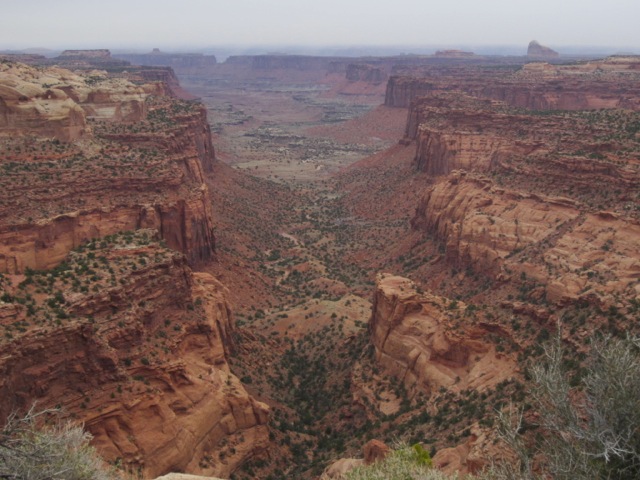
 Then we turn up the South Fork of Horse into the heart of the Maze. Once this land was sea level and totally flat, and streams meandered lazily across the flats, until what is now the Colorado Plateau got quickly cranked up to around a mile high, causing the swifter flowing streams to cut very steep canyons down through the rock, but while still following their former wildly meandering paths – thus creating this highly complex and confusing landscape.
“It’s a damned maze!” Peter and I jokingly exclaimed, as we often had to stop and study the map for minutes at a time, trying to figure which side canyon was which amidst the multitude of seemingly identical options. When at the bottom of a narrow 300′ high vertical walled canyon, there are no reference points. It is a maze. Nature is very strong here – she twists your rational mind around, both confusing and enlightening you with her tricks and her own form of logic (intentional gender reference).
We finally find the correct exit, and follow the usual ridiculously complex cairned route out into the Land of Standing Rocks, and then nicely on to the Doll House, our first camp.


DAY TWO – Doll House to French Fork
The word “camp” is actually misleading. We travel “thru-hiker” style, which means we don’t exactly “camp”; we hike until it starts to get dark, find a flat spot, eat dinner, roll out the bag and go to sleep. Then at first light we stuff the sleeping bag and bivy sack into the backpack, and start walking again. We hike as continuously as possible, stopping only because of darkness and needing to sleep. Only our third “camp” had water; this and the first two were dry, which doesn’t make much difference since we’re not really cooking or cleaning.
Leaving the Doll House at dawn, we launch across the Fins Trail. This is one of the finest trails in the United States, because it doesn’t officially exist anymore. The Park Service yanked it off the maps about 15 years ago and stopped maintaining it; fortunately I saved my old maps so still know where it goes.

One has to look quite closely to find traces of a faint path across the sandy, sage and blackbrush covered flats. Don’t you just love “trails” like this? There about 10 arches up the side canyons, known mostly to “arch-baggers” who travel to places like this for the sole purpose of finding obscure arches.
My interest was different – I had wanted to visit this place for decades before I finally made it out here – the map labels it “Ernies Country” – and since bedtime reading for me often was pouring over obscure maps, I decided I wanted to go to the place called “Ernies Country”.
 We found “Clell’s Spring”, which I had never found before, then came to “Lou’s Spring”, which is the main source of water in this country. We stopped and filled up here – our last water was 20 miles previous at the start of the Maze, and the next was expected to be in lower Happy Canyon, another 20 miles hence.
Lou’s is reliable – I had used it on two previous trips – and I again marveled and took delight at the unique nature of desert travel:
1. If you miss Lou’s, you’re in deep trouble – there isn’t so much as a damp spot on the ground for miles and miles – knowing what you’re doing is life and death out here.
2. Lou’s consists of a pipe hammered into a rock alcove, with 2 drops of water per second dripping out. So very very little – yet enough – scarcity breeds appreciation, an attitude that greatly deepens our sense of place on earth.
3. Someone carried down a metal trough and constructed a catch basin for the drips. Presumably “Lou” did this – I have no idea how it could have been managed – what a monster he and those other cowboys must have been! Us top athletes are total couch potatoes compared with those pioneers. Thanks Lou!
 We exit Ernies Country and begin the slog up the Golden Stairs, a scree slop cutting through the Organ Rock cliff band, followed by a weird long traverse to finally gain passage thru the steeper White Rim formation. Except I somehow missed the key exit point – this is after executing it perfectly on two previous trip – leaving Peter and I mustering back and forth on the side of the cliff bands looking for it.
“Casualitis” is a major affliction of mine. I’m an excellent navigator the first few times I’m in difficult country, then once I’ve been successful, I become overly casual and mess it up. Sorry about that Peter.
We finally reach the Flint Trail, crank up thru the Wingate, and after only 800M on top, make the drop into Happy Canyon.

This takes us out of Canyonlands National Park; we are now in Robbers Roost country. Hard though it is to imagine, there are far less people here than even in the Maze. It’s a committing route. We saw three people (traveling in jeeps) passing thru Standing Rocks at the end of the first day – we would not see another human for the next three.
We roll out the bags at the bottom of Happy, just short of French Fork. I light a little fire with our bar wrappers and a few twigs. The night is so dark with so many stars I can’t make out the constellations.

DAY THREE – French Fork to Sams Spring Junction
We’re under way at our usual time, a little after 7 am. Happy Canyon is total cruiser – a gravelly rather than sandy bottom, due to the slightly steeper gradient, which makes for fast, easy hiking.
 This is a really big canyon. About 30 miles long, it starts up on the plateau and ends 2,000′ lower on the Dirty Devil river, which itself drains into Lake Powell. The continuous Wingate cliffs block seemingly all entrances and exits, but here in the bottom, life is good – late winter storms have filled potholes, so after an hour or so we can fill up our bottles and relax about that.
Happy Canyon has some famous (among the cognoscenti) narrows just before joining the DD. We’re looking forward to that – one website rates them among the Best in the World. We thus might even see another person.
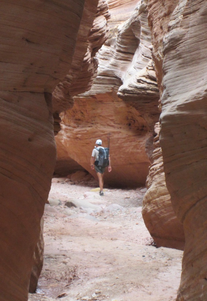 Around Noon we enter the Narrows. Very fun – after an entire morning motoring down a huge canyon with the Wingate all around us, we now are in a 100′ deep slot, touching the rock frequently as we maneuver around muddy little potholes, trying not to get our feet wet – we say it’s too cold for that – but the truth is we’re sort of squeamish, being the ultra runners that we are (or were).
The Happy Canyon Narrows are really nice, and a very nice break, but not sure if I would go Top Ten. In fact, I wouldn’t.


About 1:30pm we pop out of the Narrows to the Dirty Devil. No one likes the DD … it’s sort of an important stream/river in these parts, but it’s name kind of fits. The best way to experience it is to time a trip exactly for the 5 days when it hits flood stage in May during spring runoff, and blast down it in pack rafts. Instead, we drop into the cold muddy flow, delighted to have trekking poles to gauge the depth and keep us upright, while wondering how we managed to leave the house for all those decades before we discovered poles.

It’s really not so bad – nothing is deep or fast – just 6 miles of mud, muddy water, willows, and the occasional dry and clear flood channel. Peter puts the bit between his teeth on stuff like this; he sets an unblinking pace, clearly wanting to charge out of such business with minimal delay. Navigation nuance occupies us, as we try to link up the quicker dry flood channels, avoiding the 15′ vertical banks of muddy willows. It’s annoying to be sloshing in and out of the water 20 times, without being able to drink any of it.
 We reach the mouth of Sams Mesa Box Canyon, and hang a right – time to get out of there close the loop. SMBC parallels Happy Canyon, with the same starting and ending elevation but in maybe half the length, which gives it a steeper gradient. The changes everything – instead of the flat sands of Horse Canyon, and the gradual gravels of Happy, SMBC has rocks, boulders, and slickrock shelves – and pools of water – because it is cutting down to the bedrock instead of depositing porous sands and gravels which don’t retain standing water.
We stop for the night at the junction of Sams Spring side canyon, with a few very vidid green trees around, and a flowing trickle of water – the first clear flowing water of the trip. That night the wind blows hard, and I worry rain might make my bivy sack very uncomfortable, but the weather report, which I check religiously before any backpacking trip, is correct and wind is all we get. We later hear the tent campers at Goblin Valley State Park had to abandon their camps and drive and hour to motels because the wind was blowing their tents away.
At the bottom of SMBC, we hardly noticed.

DAY FOUR – SMBC to Hans Flat
This is definitely the crux day. I had done the Maze section on previous trips, and beta indicated Happy would be an easy canyon, which it was, but exiting SMBC was reported to be tricky. We could find three accounts:
1. Someone who reported doing it, offering no description.
2. A group of “experienced” backpackers, who really struggled, never quite making it to the bottom after trying all day to get in (online photo’s indicated “experienced” meant they were almost as old as me, which made us dismiss their reported difficulties).
3. Michael Kelsey’s guidebook description, which of course was barely coherent, but reliably indicated it could definitely be done.
 We navigated carefully upstream, checking our progress so we could start the exit sequence at the correct point, but the pouroff described by the backpackers was obvious, so we tanked up on water and confidently left the canyon floor, launching up the nearest scree tongue, which provided an exit path between bands of continuous cliffs.
We proceeded with diligence, trying to figure out then follow the route descriptions, until we were pretty much lost. At that point we gave up and climbed what looked right, and being very experienced backcountry travelers, that worked just fine. It is much easier route finding going up than it is going down, so I can definitely see how someone would have trouble trying to get in to this canyon.

Moral of the story: plot your route on Topo! or Google Earth, or find someone’s GPX file who has done it, enter the waypoints into your GPS, and off you go. Maps are helpful but do not guarantee success in terrain like this, where a tiny 20′ high cliff band will not show up and could stop you cold – GPS is a technology that really, really works.

We finally top out, and begin marching across the vast mesa top. This sure is different – everything is suddenly flat as a pancake – in minutes we can turn around and not even see that the mammoth canyon we were just in exists. We can’t see anything but the snow-covered Henry Mountains in the distance, and endless sage and prickly pear flats around us.

What an amazing country – unless you’re actually in one, one can’t even tell Robbers Roost has canyons – no wonder Butch Cassidy hid out here. “Hey”, I want to say – “there’s an entire world down there – you must believe me – I was just there!”
Our “back by 2pm” guesstimate from a few hours ago was short, as the car was still another 8 miles away, so Peter motored on ahead, while I stumbled around for a few minutes, a bit unsure of myself. I felt like Alice leaving the rabbit hole, and as soon as I did, the entrance to the hole just disappeared … had it really been there at all? And I also wasn’t sure if I was glad to have gotten out of it … or sorry that I might never see it again.


Tags: Backpacking the Maze, Happy Canyon, Robbers Roost, Sam's Mesa Box Canyon

April 26, 2013 at 7:05 am |
Very cool. Thank you for sharing.
April 26, 2013 at 7:59 pm |
As always, an amazing, wonderful story! You always make me want to go to where ever you have just been, my friend.
January 8, 2017 at 12:23 am |
the 4th day, wading water nearly up to one’s armpits, was there an alternative, the least being hiking in another time of the year? wasn’t the threat of possible health risks of exposure contemplated?
January 8, 2017 at 12:25 am |
Actually the water was fine – not fast, not cold – just real slow going.
December 22, 2021 at 11:16 am |
Fantastic account… I love exploring the areas around Canyonlands. I now have this mapped out on my Gaia for a future trek!