Referred to as “Disneyland” by Karl Meltzer, Zion National Park truly is one of the ultimate outdoor playgrounds in the West. Some my earliest memories growing up take place between the beautiful sandstone walls of the park proper. Fortunately still living in the Salt Lake City I get to visit the park often, with only a 4 hr drive between us. As a kid my Zion NP activities included short hikes, playing in the river, and experiencing a yearly concert of the Utah Symphony held at the O.C. Tanner amphitheatre adjacent to the park entrance. If you like the symphony and enjoy the outdoors this event should not be missed.
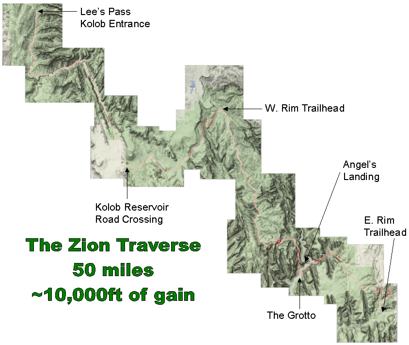
My curiosity for what else the park had to offer began to expand as I’ve dabbled in the sports of rock climbing, canyoneering, road biking, and long distance trail-running throughout the years. My perspective of the park is always changing and several years ago while inspecting a park map I couldn’t help but notice the obvious connection of trails that literally traverse the entire park. The route starts at Lees Pass in the northwest corner of the park, accessed just off of I-15, and goes to the southeast corner of the park at the East Rim Trailhead. As any long-distance trail runner infused with an obsession for maps would do, I began planning.
On April 6th, 2008, while on another trip in the area, I tackled a large chunk of the run. It was a ~39 mile run from the East Rim Trailhead (near the east entrance of the park) out to the West Rim Trailhead and back to the Grotto. It was a great training run, I learned about 1/2 of the route, realized that there was still too much snow on the high plateaus, but more importantly I realized that I had to do the entire thing.
Upon returning back to SLC, the traverse began to pull at me and I was ready to head right back down. April 14th, I contacted friend and fellow La Sportiva runner Karl Meltzer and figured I’d see if I could talk him into abandoning his planned run of the Bonneville Shoreline Marathon and join me for the Zion Traverse. Much to my amazement, the next day he called and said he was in.
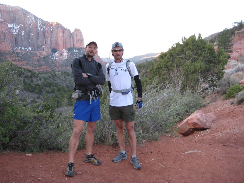
The logistics were easy, especially since I had 2 friends who wanted to run a portion of it and the fact that my girlfriend, in her infinite kindness, offered to shuttle folks around. So on April 19th, 2008 Karl and I took off from Lees Pass just after 7 AM, our next milestone being the West Rim Trailhead, some 23 miles away.
The entire traverse can be broken down into 3 sections:
- Lees Pass to West Rim Trailhead (~23 miles)
- West Rim down into the park at the Grotto (~14 miles)
- Out to the East Rim Trailhead (~11 miles)
Section 1

The run down La Verkin Creek was beautiful. Crisp, cool conditions greeted us as we slowly lost elevation from the parking lot down to the creek. Karl was using this run as training run for his up and coming (AppalachianTrail) AT record attempt in August. This involved testing out some new video equipment. Armed with a small video camera where the lens was stored in a small flashlight type case with a cable running to a small pack where the batteries and memory card were located, we spent some time at the creek getting it figured out and taking some sample footage. (see movie at the bottom of the post).
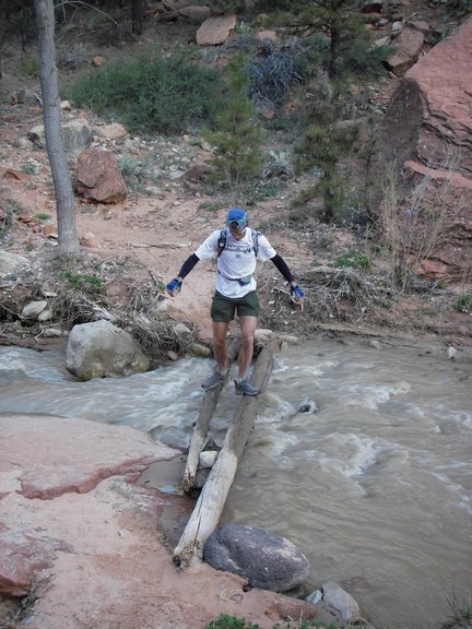
LaVerkin creek was low and easy to pass on a couple logs. The crossing was followed by a brief climb, and then started heading south into Hop Valley, a beautiful open and relatively flat section.
We made it through the valley quickly, which ended with a short climb up to a plateau. Despite the fact that I had organized the journey and studied the maps I somehow managed to take a wrong turn on top of this plateau. Karl was slightly behind at this point because he had stopped to fix his shoes and fiddle with the camera. He more intelligently took the correct turn which meant we were headed in different directions at this point.
About a mile down the road I was amazed that Karl hadn’t caught me yet. So, I dropped my supplies (still thinking I was on the correct path and would be back), ran the mile back and realized that it was actually me who had taken the wrong path, damn. I kicked myself, sprinted back to my supplies and then back to the correct turn and took off to catch Karl. I tried to tell myself that I should be happy that I got some extra miles in…. 🙂
About a mile later I reached the Kolob Reservoir road where the trail crosses the road and turns into what is called the Connector Trail. The trail is not well defined here and I could tell that Karl also kept losing the trail based on his footprints. Eventually it became cleared up, but you could tell it still doesn’t see much traffic, rightfully so as it’s not the best section of the run. I was really trying to make up some time as I knew Karl was ahead of me and I felt bad about getting lost. It wouldn’t be for another 7 or 8 miles before we’d meet again. The connector trail eventually hooked up with the Wildcat Trail which is really great. Several miles later a long traverse section across the western side of Wildcat Canyon allowed me to see Karl and we were able to exchange signals. The creek in Wildcat was nice and allowed me to cool off a bit after running hard trying to catch Karl. We jogged into the West Rim Trailhead together where we anticipated support (i.e. food/water).
Section 2
Due to a road closure Mindy (my girlfriend) had not been able to drive down to the trailhead so instead my 3 friends (Ryan, Mike, and Becky) packed in some “select” supplies and a gallon of water before the three of them started a run from here to the East Entrance. Extremely nice of them, but Karl and I quickly discovered that we’d have to ration what we had to the end, which added to the adventure. After filling up on water and sorting out what food we had left we took off down the West Rim Trail. It is relatively flat until the descent into Potato Hollow followed by a few short climbs. It really starts to get beautiful from this point.
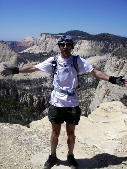
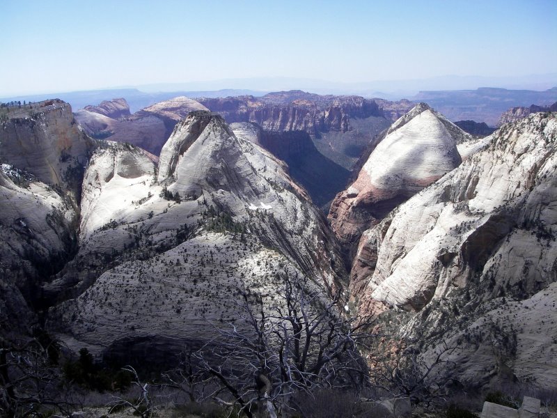
We shot some video, took some photos and enjoyed the rolling nature of the West Rim Trail. At Cabin Springs a big descent begins down into the park with incredible views the entire way. It’s worth saving your legs for this descent so you can move expeditiously on the largely “paved” descent. We had only seen a few folks all day until we neared Angels Landing at which point the droves of tourists began. We didn’t slow, however, from comments like…. “showoffs!”. I always have to laugh running Angels Landing with the wide assortment of comments from folks.

Section 3
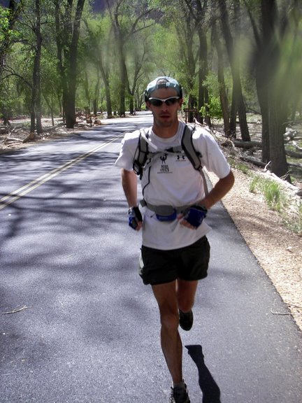
We took a brief beak at the Grotto, filling up on water and soaking ourselves. It was so nice. We wanted to be feeling fresh for the 1mile of pavement. 🙂 I thought it was so funny to be running on the road with one of the best trail runners around. We joked about training for Badwater, but without a “white line” it just wasn’t the same. Plus, it wasn’t 130F so it really wasn’t great training. Here’s a classic shot of Karl the road runner.
From here all we had was one big hill to Stave Springs and then ~6.5 miles out, a total of only 11 miles from left from the Grotto to the end. We were still rationing calories and salt as we made the climb and then picked up the pace on the long downhill out. Stave Springs provided some nice water and was very welcome to cool myself again. At the end we were greeted with…. nothing. We had to hitchhike back to Springdale where we met up with the entire group of friends for a great feast of pizza and beer at the Zion Pizza and Noodle. Karl amazed everyone when he drank about 1.5 pitchers of beer and an entire pizza by himself. I’m not sure where it all went?
We did the run in 10 hrs 24 minutes, which was a fun pace that allowed us to shoot some video/pictures, take in the scenery, and also for me to get lost and log some extra miles. If one did it correctly it is just under 50 miles with about 10kft of vert. Below are some pictures of the 3 sections.
Maps
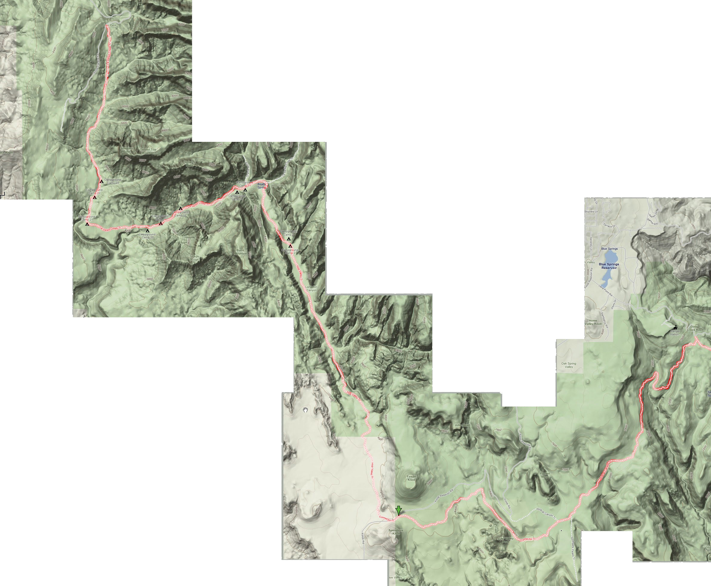
Part 1: Lee’s Pass to West Rim Trailhead (23 miles)
(click for larger version)
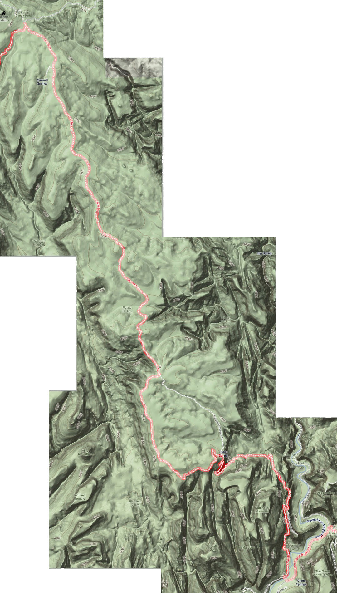
Part 2: West Rim Trailhead to the Grotto (14 miles)
(Click for larger version)
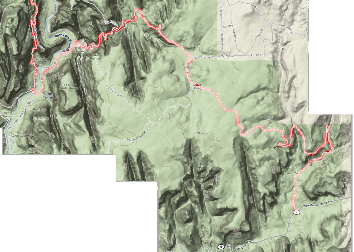
Part 3: the Grotto to East Rim Trailhead (11 miles)
(Click for larger version)
Movie
Closing Thoughts
Upon further research this linkup has been done several times! Bo Beck (who runs a great website) from St. George, a very accomplished zioneer, has done it 3 times with a PB of 14 hrs 25 min, see report here. And word has it that friends of his also did it slightly quicker recently. So, while Karl and I didn’t end up doing something completely new we certainly had fun, did it in a record time (from what we can tell) and might go back in the Fall with speed in mind. I’d recommend this journey to anyone looking for a grand adventure in beautiful Zion National Park.
Jared Campbell – May 26, 2008
Tags: 50 miles, Jared Campbell, Karl Meltzer, Traverse, Zion

May 26, 2008 at 4:20 pm |
Wow! I am impressed guys! Kudos!
~tanya
http://www.zionnational-park.com
May 26, 2008 at 4:33 pm |
Great trip, great report! You even managed to include a video. I’m glad I badgered you to write this up 🙂 I agree it’s a highly recommended route … I never did it due to the shuttle issue, but turns out you didn’t much need it.
May 26, 2008 at 7:02 pm |
That is absolutely epic. Now on the list. I’d like the camera setup specs if possible.
May 26, 2008 at 10:26 pm |
Thanks Tanya, the site that you and Bo run is quite useful, nobody else out there documents the “off the beaten path” things to do in the park. So, Kudos to you!
Buzz, sorry it took me a bit to write it up, I wanted to make sure I got enough detail.
George, I’ll check with Karl on the name of the camera again. In the end, I am not all that impressed with the quality. It’ records to SecureSD and shoots in 640×480. It’s kindof heavy, but the fact that you can carry it like a flashlight is certainly cool. Plus it had a small LCD where you could review what you just shot. I’ve been very impressed with the GoPro Hero head-cam, which is very light, runs off AAA batteries, and take unbelievably good video (in terms of quality). Check it out.
Thanks
Jared
June 28, 2008 at 6:40 am |
Karl,
What did you use for shoes and a pack for this trip? Couldn’t identify them in the pics.
Lance
July 31, 2008 at 2:20 am |
[…] memories growing up?�take place?�between the?�beautiful sandstone?�walls of the park proper.?�https://adventurerun.wordpress.com/2008/05/26/zion-traverse/CONDOR VIEWING DAY – RedOrbitThe Day of the Condor event is free and runs from 9 am to 2 pm at Lava […]
October 15, 2008 at 3:08 pm |
Hey Jared,
Thanks for the EXCELLENT TR on this! I’ve been looking for info on this run and found this link off Peter Bakwin’s site. Can’t wait to run it soon!
Thanks!!
– Chris
May 7, 2009 at 2:24 pm |
UPDATE: On May 2, 2009, Chris Gerber did do this run … along with 16 others! It was a big group from Boulder.
Andy Skurka went E to W and now has the FKT at 9:27. Peter Bakwin led the W – E contingent with 10:30. Others in that group did it in grand style: a detour to rarely visited Kolob Arch (2nd longest in the world) and even a side trip up oft visited Angel’s Landing.
With easy tho distant access from both ends and the middle, this should become a much more popular route. Every step of it is excellent; there are no bad sections. The feeling was that E – W might be easier.
June 19, 2009 at 12:19 pm |
Yes, this was huge fun!! It’s one of the most amazing runs I’ve done… just fantastic!
– Chris
November 12, 2009 at 5:12 pm |
[…] traverse is so far relatively small, an oversight that will no doubt be corrected in time. (Go here for a fine account of the whole enchilada, as run by Jared Campbell and Karl […]
February 24, 2011 at 9:19 am |
Update: Matt Hart now has the FKT of 7:58 set May 12, 2010.
April 21, 2011 at 10:44 pm |
Historical note. The Wasatch Alpine Striders were the first documented group to push out on this run. They would use the late Steve Utley’s cabin in Springdale as their base, and I believe John Moellmer was the first to actually do the entire Zion Train, as it was called then and still is called now. I once ran from the Grotto to Lee Pass and had to filter water from a cow hoofprint. Yuck. That was back when cows were still allowed in Hop Valley.
Great work, you guys. In future, in respect to Irv and John and especially Steve, please call it the Zion Train. Thanks!
November 13, 2011 at 4:49 pm |
[…] felt like Davy Crockett. The Trans Zion – a wonderful run that traverses Zion National Park from one end to the other – was […]
November 13, 2011 at 5:07 pm |
You can keep the record – well done!
But the trail looks great. It would be a three-day hike for me.
March 29, 2012 at 12:12 pm |
[…] this incredible route and had taken some sweet video. Karl was pretty excited about the run (blog report on it w/video). I had never been to zion, but the seed was […]
December 28, 2012 at 12:25 pm |
My brother recommended I may like this blog. He was entirely right.
This post actually made my day. You can not consider
just how so much time I had spent for this information!
Thank you!
May 2, 2013 at 9:22 pm |
April 6, 2013 – Travis Macy ran a supported 7:26:46, W to E.
http://www.followtravismacy.blogspot.com.
February 25, 2015 at 4:03 pm |
[…] Zion National Park. It has been most often tagged the “Zion Traverse”. However, in Jared Campbell’s wonderful report of his and Karl Meltzer’s trip in 2008 HyperPhil Lowry, a Utah local and […]